Mount Watatic
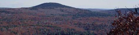
Mount Watatic allows public access to a parcel that contains 231 acres in the town of Ashby, which was formerly the old Mt. Watatic ski area. Some additional 50 acres, which includes the summit and Nutting Hill, is in the town of Ashburnham. The landscape is diverse with open ski slopes and rock outcroppings in various stages of succession, and remnants of old growth along steep forested slopes. The parcel abuts land held by DCR, Fish & Wildlife and Fitchburg Rod & Gun. The intersection of two major trail systems, the Wapack and Midstate, offer plenty of hiking, mountain biking, snowshoeing and skiing opportunities. These bald summit gives 360 degrees of panoramic views; to the east, the Boston sky line, to the south, Mt Wachusett, to the west, Mount Monadnock and north to the Wapack Range.
- Size
- 231 acres
- Directions
- From 119 and the common go west on 119 4.8 miles. There is a sign and parking area on right.
- Parking
- In the parking area and along 119 off the road.